
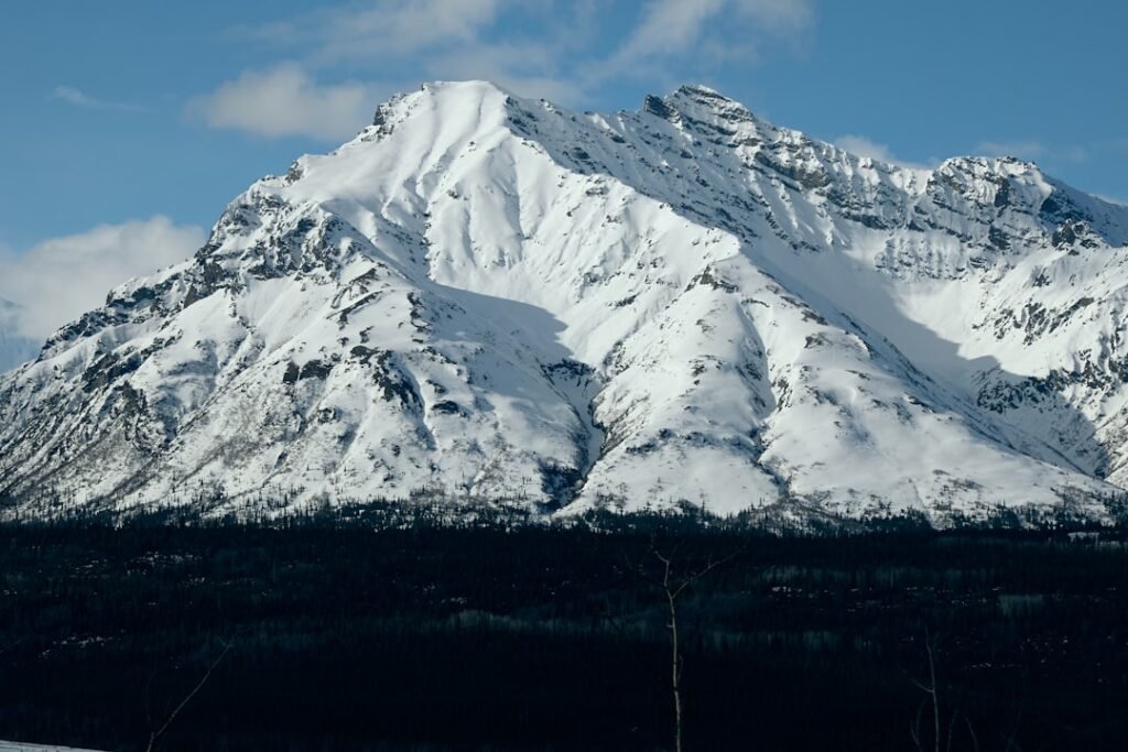
The recent re-evaluation of the 2015 Taan Fjord event in Alaska confirms it as the second-largest megatsunami ever recorded, a stark reminder of the escalating Alaska megatsunami climate risk. This colossal wave, triggered by a massive landslide into a narrow fjord, underscores a critical and growing concern: as global temperatures rise and glaciers recede, the likelihood of such devastating natural phenomena increases. New research highlights how climate change is destabilizing landscapes, turning previously stable slopes into potential triggers for enormous displacement waves. Understanding and mitigating these hazards demands sophisticated analytical approaches, moving beyond historical data to predictive modeling that can anticipate future threats.
580 ft
Maximum wave height of 2015 Taan Fjord event
180M
Tons of rock displaced in 2015 landslide
2015
Year of the Taan Fjord megatsunami
The Anatomy of a Climate-Driven Catastrophe
Megatsunamis are distinct from typical tsunamis, primarily generated by massive, sudden displacements of water, often from landslides. In glacial environments, this phenomenon is exacerbated by climate change. As glaciers melt and retreat, they often leave behind oversteepened, unstable slopes previously supported by ice. These exposed slopes, often composed of fractured rock and loose sediment, become highly susceptible to failure. A significant seismic event, heavy rainfall, or even the sheer gravitational force can trigger a massive landslide into a fjord or lake, displacing an immense volume of water and generating waves of extraordinary height and destructive power. The 2015 Taan Fjord event, originally estimated to be around 193 meters (633 feet) high and now refined to 177 meters (580 feet) by a detailed re-analysis, demonstrated this principle devastatingly. The sheer scale of such events necessitates a paradigm shift in how we approach hazard assessment, moving beyond historical averages to dynamic, climate-informed risk models. The scientific community’s focus on these hazards has seen cycles of intensity, much like the broader understanding AI winter cycles that influence technological development and investment. However, the current climate imperative ensures sustained attention to these critical environmental threats.
Quantifying the Unpredictable: Data Science in Megatsunami Forecasting
Forecasting these complex events is a monumental challenge. The confluence of geological instability, glaciological dynamics, and meteorological factors creates a highly unpredictable system. However, advancements in data science and remote sensing are providing unprecedented tools for risk assessment. High-resolution satellite imagery, such as that provided by Sentinel-1 and Planet Labs, allows for continuous monitoring of glacier retreat rates and changes in slope morphology. Lidar (Light Detection and Ranging) surveys provide highly accurate topographical data, revealing subtle deformations and potential failure zones on mountainsides. Seismic sensors, both terrestrial and subaquatic, can detect micro-seismic activity that might precede a larger landslide, offering crucial early warnings. Furthermore, bathymetric data, which maps the underwater topography of fjords and lakes, is essential for modeling wave propagation and impact zones. Integrating these diverse datasets, often massive in scale and complexity, requires sophisticated computational methods. Machine learning algorithms can identify patterns and anomalies indicative of increasing instability, correlating them with environmental variables like temperature fluctuations, precipitation, and seismic events. This data-driven approach moves us closer to a proactive stance against these natural disasters, providing insights that were previously unimaginable. The research on the Taan Fjord event, for instance, relied on detailed post-event analysis using advanced imaging and modeling to reconstruct the landslide and wave dynamics, as reported by BBC News.

| Region | Glacier Retreat Rate (m/year) | Slope Stability Index (0-1) | Megatsunami Potential |
|---|---|---|---|
| Southeast Alaska | 15-30 | 0.2 – 0.4 | High |
| Norwegian Fjords | 10-25 | 0.3 – 0.5 | Moderate to High |
| Patagonian Andes | 12-28 | 0.25 – 0.45 | High |
From Cloud to Edge: Deploying Predictive Models for Real-time Alerting
The computational demands of processing vast environmental datasets and running complex geological and hydrodynamic simulations are immense. Cloud computing platforms offer the scalability required for training sophisticated AI models, enabling researchers to analyze historical events and simulate future scenarios. However, for real-time monitoring and immediate alerts in remote and often infrastructure-poor regions, the architectural decision between Edge AI vs Cloud AI becomes paramount. Edge AI, where processing occurs closer to the data source (e.g., on remote sensors or local gateways), can significantly reduce latency, making it ideal for critical applications like early warning systems for megatsunamis. Imagine a network of interconnected sensors deployed across vulnerable fjords, continuously monitoring slope stability, water levels, and seismic activity. These edge devices, equipped with pre-trained AI models, could detect anomalous patterns indicative of an impending landslide and trigger immediate, localized alerts to nearby communities and emergency services, even if internet connectivity is intermittent. This distributed intelligence architecture is crucial for bridging the gap between sophisticated modeling and practical, on-the-ground disaster preparedness, especially in the vast, rugged terrains where the Alaska megatsunami climate risk is most pronounced. The challenge lies not just in predicting the event, but in ensuring that the prediction translates into timely action, a domain where the optimal deployment of AI infrastructure is key. As highlighted by analyses in publications like MIT Technology Review, the application of AI to climate challenges is rapidly evolving, demanding innovative architectural solutions.
“The sheer power of these climate-driven megatsunamis demands that we leverage every technological advantage, from satellite surveillance to advanced AI. It’s not just about understanding the past, but about predicting and protecting against the future, especially as our planet’s stability shifts.”
— Dr. Elara Vance, Lead Glaciologist & AI Risk Modeler, Arctic Research Institute
The Economic and Societal Imperative for Proactive Risk Management
The human and economic toll of megatsunamis is catastrophic. While the 2015 Taan Fjord event occurred in an uninhabited area, its sheer scale demonstrates the potential for immense destruction if such an event were to strike a populated coastline. Coastal communities, critical infrastructure like ports and energy facilities, and delicate ecosystems are all vulnerable. The cost of disaster response, recovery, and rebuilding far outweighs the investment in proactive risk management and early warning systems. Beyond immediate physical damage, there are long-term impacts on tourism, fishing industries, and indigenous communities whose livelihoods are intrinsically linked to these environments. This makes the development and deployment of advanced predictive analytics not merely a scientific endeavor but an urgent societal and economic imperative. Governments, research institutions, and private sector innovators must collaborate to build resilient systems. This includes investing in comprehensive mapping, continuous monitoring infrastructure, and the development of robust, interpretable AI models that can provide actionable intelligence. The insights gleaned from studying events like the Alaska megatsunami are not just academic; they inform policy, guide urban planning, and ultimately save lives and protect economies. The long-term implications of climate change on geological stability mean that this Alaska megatsunami climate risk will only continue to grow, making sustained investment in smart solutions non-negotiable.
🛰️
Satellite Monitoring
Utilize high-resolution imagery and LiDAR for continuous observation of glacial retreat and slope stability.
⛰️
Geohazard Modeling
Develop AI/ML models to predict landslide triggers and simulate wave propagation based on geological and climatic data.
🔔
Early Warning Systems
Implement Edge AI-powered sensor networks for real-time detection and rapid dissemination of alerts to vulnerable populations.
🛡️
Community Preparedness
Facilitate public education and infrastructure hardening based on data-driven risk assessments and predictive insights.
← Scroll to explore →
🚀 How A Square Solutions Can Help
Turn This Intelligence Into Business Growth
We build AI-powered digital growth systems that turn emerging intelligence into revenue — through SEO automation, content systems, web infrastructure, and analytics.
📢 Business advertising partnerships available — reach our growing audience of tech decision-makers. Get in touch.
Frequently Asked Questions
What causes megatsunamis related to glaciers?
Megatsunamis in glacial regions are typically caused by massive landslides that plunge into fjords or lakes. These landslides displace enormous volumes of water, generating exceptionally large waves. The underlying cause is often geological instability exacerbated by glacial retreat.
How does climate change increase this Alaska megatsunami climate risk?
Climate change accelerates glacier melt, removing the ice support that previously stabilized mountain slopes. This leaves behind oversteepened, fractured rock faces that are more prone to landslides. Increased meltwater can also lubricate these slopes, further raising the risk of catastrophic failures and subsequent megatsunamis.
Can AI predict these events accurately?
AI and machine learning are increasingly used to analyze vast datasets from satellites, LiDAR, and seismic sensors. These models can identify subtle patterns and anomalies indicative of increasing slope instability, improving our ability to forecast high-risk areas and potentially provide early warnings. While perfect prediction remains challenging, AI significantly enhances risk assessment.
What are the limitations of current predictive models for megatsunamis?
Current models face limitations due to the inherent complexity of geological systems, the difficulty of obtaining continuous, high-resolution data for all remote regions, and the challenge of accurately modeling chaotic events like massive landslides. While AI improves pattern recognition, the precise timing and magnitude of a landslide can still be difficult to predict with absolute certainty.